Powder Predictor
Guess what? Still more snow on the way for Vail, Beaver Creek this week
Southern mountains finally get a break
Another shot of snow arrives Wednesday, with Pacific moisture stretching from Hawaii to Utah under strong low pressure. Mild temps for the past 48 hours will recede slightly as our next system moves into the interior West.
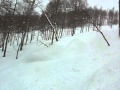
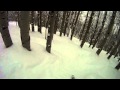
Expect snowfall at the highest elevations Wednesday morning as a cold front moves across Colorado during the day, giving resort areas in the northern and central mountains a good dosing of snow.
Thursday looks to be the powder day of the week. Any snow that falls on Wednesday will be light (1-2 inches) and more along the lines of graupel. Expect 5-10 inches on the Thursday morning report for Vail/Beaver Creek, with snow intensifying Wednesday night.
And if timing is right, Aspen/Snowmass could see as much as 8-14 inches by the Thursday morning report. Again, temps for Wednesday look mild as the cold front slowly moves across our area.
Expect on-mountain highs in the 20's and 30's with overnight lows in the teens as the front passes. Winds will be from the west shifting to the northwest as energy moves to our south. Thursday will be colder with temps in the low 20's and gusty winds from the west and northwest.
Finally, our friends in the southwest part of the state will have a good shot of big snow if temperatures can stay cold. A strong jet stream and ample moisture has the makings for your typical San Juan storm. Cold air is all that may be missing.
It's been a balmy start to the southern Rockies ski season, but winter has not even started. One week until the big day, and a lunar eclipse too boot. For now, we'll welcome another powder day.
Enjoy!
![]() 0 Comments on "Guess what? Still more snow on the way for Vail, Beaver Creek this week"
0 Comments on "Guess what? Still more snow on the way for Vail, Beaver Creek this week"
Be the first to comment below.
 Vail Town Council to weigh new plan to redevelop T...
  All about indexes
  Transforming your social security into a winning r...
  Pass sales, real estate transactions, revenues inc...
  Vail Valley native with passion for Biophilic inte...
  Land Trust, ECO Trails, Vail Resorts team up to cl...
  EUROVISION named Host Broadcaster for 2015 World A...
  Vail Resorts brings back Lindsey Vonn's 'School of...
  Hundreds turn out for 2015 World Championships vol...
  Eagle County Senior Health Expo and 9th Annual Hea...
  Final race of Vail Mountain Trail Running Series s...
  Before you write your will ...
  2015 World Ski Championships volunteer recruitment...
  Ascent Sotheby’s International Realty in Vail an...
  CDOT outlines road closures for local stages of US...
  Italian artist creates unique trophies for Vail, B...
  Vail Recreation District once again hosting Jake W...